Walks

Walks around Finchingfield

Footpaths and quiet lanes lead out of the village into gently rolling North Essex farmland, along Finchingfield Brook and the River Pant. Two circular walks published by the Hundred Parishes Society pass through the village, and both are free to download.

Route details were checked against the latest guides in October 2026. Paths can be diverted, so take the current guide and a map.

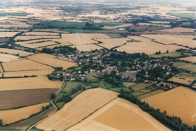
Aerial view of Finchingfield and the farmland around it

Walk 103: Finchingfield and Great Bardfield

4.5 miles (7 km) Circular Fairly flat Starts in Finchingfield

Start: the small public car park on Stephen Marshall Avenue, at the southern end of the village (CM7 4LZ), which has public toilets. The walk runs anticlockwise.

The route: it heads west along the Winsey Chase path, with views of Great Bardfield’s brick tower windmill (now a private house), then follows the River Pant past a weir and the Copford Hall gauging station to Bridge End, where you cross the river on a wooden footbridge beside the old road bridge. In April and May, look for oxlips in Piper’s Meadow. You come back past the remains of Great Bardfield watermill, along Mill Road, then through the churchyard and out under the Guildhall archway to the green.

Underfoot: mainly rural and mostly away from busy roads, on generally well-kept paths that can be muddy in places. The old stiles have all been replaced with gates. One footbridge over Finchingfield Brook still has a metal barrier at each end, and later there’s a low fence to step over. There are short stretches of lane and road; on Mill Road, use the pavement on the left. The steps from the Guildhall archway come down straight onto the road, so take care.

Food and drink: the pubs and tearooms around the green are at the end of the walk; see Eat & drink.

Walk 103 guide and map (PDF) ↗ · Guide last updated 16 October 2025
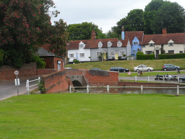
The bridge and pond on Finchingfield green

Walk 104: Great Bardfield and Finchingfield

6.3 miles (10 km) Circular Fairly flat One stile

Start: Great Bardfield, about 2 miles south. There’s no car park at the start; park on the road near the war memorial (CM7 4RF). The walk runs clockwise and passes through the middle of Finchingfield, so you can also join it on the green.

The route: from Great Bardfield’s High Street it follows the Tom’s Lane bridleway and crosses the Spains Hall Estate on a public footpath, with the red-brick Elizabethan Spains Hall in view. It then comes into Finchingfield, with views of the church and windmill, passes the war memorial, the green and the pond, and heads south beside Finchingfield Brook. Back in Great Bardfield, the church has a rare 14th-century stone rood screen.

Underfoot: mostly away from busy roads, but parts get quite muddy in winter, and the guide suggests it’s at its best in summer. The Tom’s Lane bridleway can be muddy, and the narrow fenced path beside the brook south of Finchingfield runs for more than half a mile; it’s often muddy in winter, and the guide advises against shorts in summer. The guide gives a winter alternative along the B1057, where the pavement runs out: walk in single file, facing the traffic.

Food and drink: Great Bardfield has two pubs, and Finchingfield’s pubs and tearooms are around the green.

Walk 104 guide and map (PDF) ↗ · Guide last updated 6 May 2024

Neither guide gives a walking time. The Hundred Parishes Society asks walkers to take responsibility for their own safety, since paths are sometimes diverted and conditions change with the weather. You can suggest improvements to a route through its feedback page ↗.

Before you go

Maps, mud, dogs and footpaths

Maps and route changes

Both walks are on OS Explorer 195 (Braintree & Saffron Walden), at 1:25,000. The current printed edition dates from 2015, so recent footpath diversions may not be on it: part of Footpath 2 near Robin Hood End, for example, was diverted in February 2026. Essex Highways’ rights of way map ↗ shows every public path in the county, with current closures and diversions. It’s a guide only, not the legal Definitive Map.

Mud and the seasons

The Spains Hall Estate describes its soils as mostly clay, which gets waterlogged quickly after prolonged rain, so wear boots from autumn to spring. After very heavy rain the brook can flood the green and nearby roads; see Winter visits for the flood check to make before you set out.

Dogs and livestock

The Countryside Code asks you to keep dogs under effective control and on a lead around livestock, and to bag and bin dog poo. If cattle or horses threaten you, let go of the lead so your dog can get away. Since March 2026 the fine for a dog attacking or worrying livestock in England and Wales is unlimited, and the law now covers roads and paths too.

On roads and lanes

Both walks use short stretches of lane or road. Where there’s no pavement, the Highway Code says to walk on the right, facing oncoming traffic, in single file on narrow roads, and to wear something bright in poor light.

Spains Hall and its estate

Spains Hall is a private home: Jamie Oliver bought the Hall in 2019, and the Ruggles-Brise family, who lived there from 1760, still own and farm the estate around it. The estate isn’t open to the public beyond its public footpaths, so keep to those. It asks walkers to respect any taped-off areas during forestry work and to keep dogs on leads nearby. The beaver enclosures on Finchingfield Brook aren’t open to visitors.

The Countryside Code

Leave gates as you find them, stay on marked paths even when they’re muddy, use gates and stiles rather than climbing field boundaries, and take your litter home. When you park, don’t block gateways or driveways. Read the Countryside Code ↗

Parking and toilets

Walk 103 starts at the Stephen Marshall Avenue car park (CM7 4LZ), which has the village’s public toilets. It’s small and can fill up on warm weekends, so avoid summer Sunday afternoons if you can. More on parking and getting here.

Report a problem

Overgrown, blocked or broken paths, gates and stiles can be reported to Essex Highways through its Tell us ↗ form. Pin the exact spot, add photos and quote the path number shown on the rights of way map. For an urgent safety problem, call 0345 603 7631.

Walk with a group

Local Ramblers groups sometimes lead walks from the village. In August 2026 Uttlesford Ramblers led a 5.5-mile circuit from The Fox on the Green to Wethersfield and back along the river, and the group welcomes visitors as well as locals. Chelmer & Blackwater Ramblers have walked from Great Bardfield past Spains Hall to Finchingfield, and let non-members try a few walks first. Upcoming walks are listed on each group’s page. Uttlesford Ramblers ↗ · Essex Ramblers groups ↗

Further afield

The Hundred Parishes Society publishes circular walks from the neighbouring villages too, such as Walk 179 at Wethersfield (5 miles, no stiles) and Walk 145 around the Sampfords (4.5 miles); find them on its Other walks page ↗. None of Essex’s long-distance paths passes through Finchingfield. The closest are the Harcamlow Way near Thaxted, about 5 miles west as the crow flies, and the Flitch Way ↗, a flat, traffic-free former railway line of about 15 miles between Braintree and Bishop’s Stortford, about 7 miles south near Rayne.

Know a path we should add?

If a route has changed or you know a good local walk, let us know and we’ll check it.

Tell us